TolTEC Commissioning Data
2022 Data
TolTEC 2022 Commissioning Data Release
These maps were acquired during commissioning observations of TolTEC in December 2022, and are released after careful science validation by the Science Team.
Flux Calibration:
Flux calibration factors for the M1, MonR2, and 3c286 observations were determined from a beammapping observation of J1159+292 (Ton 599 or 4C+29.45) which was taken on December 19, 2022. We use the calibration from the flux estimates from ALMA and find agreement within 10% in each band. We see an additional scatter of approximately 10% when comparing our point source photometry to other radio galaxies monitored by ALMA, which is likely due to both the uncertainty in our flux calibration and the variable nature of the radio galaxies. Therefore, we conservatively estimate the flux uncertainty of the following images to be 15-20%.
M1
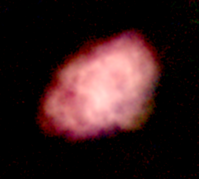
Three color image of M1 with red=TolTEC 2.0mm, green=TolTEC 1.4mm, and blue=TolTEC 1.1mm.
| Date | 12/17/2022 |
|---|---|
| Mapmaker | Citlali iterative Jinc mapmaker (175 iterations) |
| S/N cut | 2.5 |
| Units | mJy/beam |
| Project | 2022-C1-COM-15 |
| RA/Dec Coords | (05h34m32.36s, +22d01m46.9s) |
| Map Size | 12.0’ x 10.0’ |
| Map pattern | Raster |
| Integration time | 1800 seconds |
| Estimated calibration error | 15-20% |
Note on Astrometry: Astrometry was corrected so that the bright central emission coincides with the ALMA emission at 93 GHz and with the JCMT knots at 850 microns by applying a 6.65 arcsecond offset at 45.88° degrees. The astrometry error in the 1.1 mm is ~2.5 arcseconds; other bands are under analysis.
Note on Photometry: The estimated statistical uncertainty level related to the flux recovered at 1.1 mm is about 16% of the total flux recovered at the source. At 1.4mm and 2.0 mm, the statistical uncertainty levels are about 17.21% and 6%, respectively.
Citlali is a filter and bin mapmaker written by Michael McCrackan and described in this SPIE paper. The iterative mapmaking implementation closely follows the algorithm described in Chapin et al. 2013.
TolTEC M1 total intensity maps at 1.1, 1.4, and 2.0mm are available here: M1 Download Page
MonR2
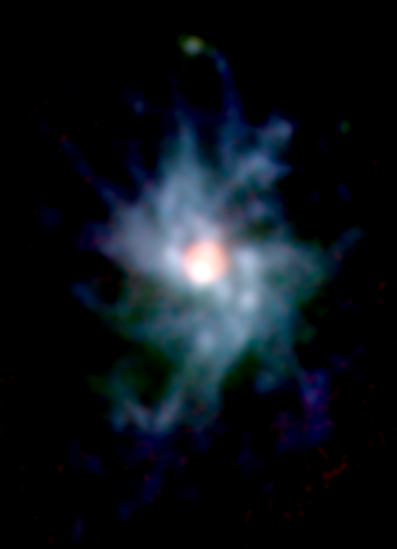
Three color image of MonR2 with red=TolTEC 2.0mm, green=TolTEC 1.4mm, and blue=TolTEC 1.1mm.
| Date | 12/20/2022 |
|---|---|
| Mapmaker | Citlali iterative Jinc mapmaker (175 iterations) |
| S/N cut | 2.5 |
| Units | mJy/beam |
| Project | 2022-C1-COM-06 |
| RA/Dec Coords | (6h7m46.30s, -6d23m9s) |
| Map Size | 9.4’ x 8.5’ |
| Map pattern | Lissajous |
| Integration time | 604 seconds |
| Estimated calibration error | 15-20% |
Notes:
Pointing offsets relative to AzTEC source positions (Sokol et al. 2019) vary between 2-5”.
TolTEC MonR2 total intensity maps at 1.1, 1.4, and 2.0mm are available here: MonR2 Download Page
3C286
| Date | 12/20/2022 |
|---|---|
| Mapmaker | Minkasi (no-HWP files) and demodulation pipeline (CRHWP files). See Note 5 |
| Units | mJy/beam |
| Project | 2022-C1-COM-09 |
| Map Size | 6’ x 6’ |
| Map pattern | Lissajous (no-HWP files) and Raster (CRHWP files) |
| Integration time | 300 seconds (no-HWP files) and 1800 seconds (CRHWP files) |
| RA/Dec Coords | (13h31m8.30s, 30d30m33s) |
| Estimated calibration error | see notes 3 and 4 below |
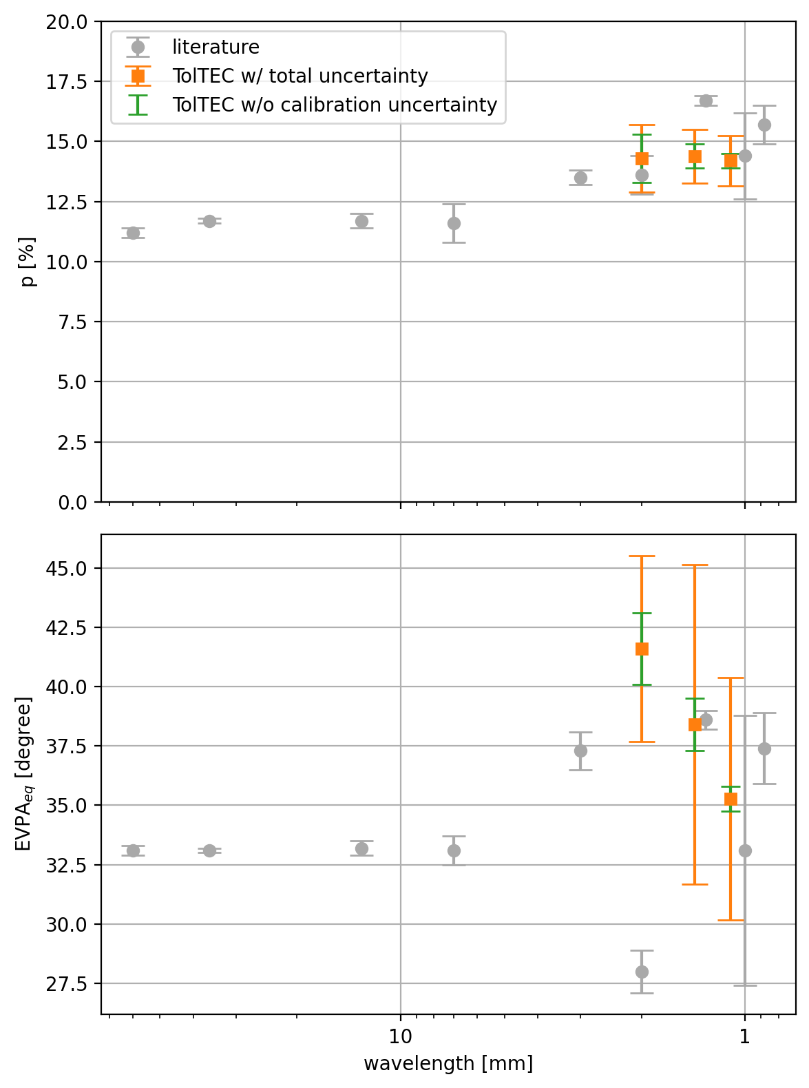
Measured percentage (top) and angle (bottom) of polarization from a preliminary analysis that combines data collected with and without the spinning HWP. Literature values from Hull et al. 2016, Agudo et al. 2012, Ritacco et al. 2017 and Nagai et al. 2016
Note 1: The target was observed in two modes. One mode did not use a half-wave plate (no-HWP) and the other mode employed a continuously rotating HWP (CRHWP). Results are provided in separate data files. The CRHWP is not designed to work at 2 mm so CRHWP results are not given for this band. The no-HWP mode data was reduced using the Minkasi data reduction pipeline. For the CRHWP data, the observations were filtered with a bandpass to isolate the signal band, and then demodulated. A simple filter and bin method was then applied to clean the result. As a result of the filtering, artifacts appear in the CRHWP maps - see elongated negative-signal regions North and South of the point source.
Note 2: The reference coordinates are modified so that the target will appear centered at: RA(2000) = 13h 31m 8.3s, DEC(2000) = 30d 30m 33s.
Note 3: For the case of no-HWP files, total intensity calibration uncertainties are 15-20%. For the case of CRHWP files, I, Q, U maps have been scaled so that the I maps for no-HWP and CRHWP match.
Note 4: Polarimetric calibration uncertainties are as follows: No instrumental polarization corrections have been applied to these data, and we estimate that this introduces a systematic error of plus or minus 0.01 to each of the quantities Q/I and U/I. In addition, absolute calibration of the polarization position angle is uncertain to +/- 3 degrees for the No-HWP mode data, +/- 8 degrees for the 1.1 mm CRHWP mode data, and +/- 12 degrees for the 1.4 mm CRHWP mode data.
Note 5: Minkasi is a maximum likelihood mapmaker originally written by Jonathan Sievers (Minkasi GitHub) used by the MUSTANG-2 team. See, for example, Romero et al. 2020.
I, Q, U Stokes parameter maps and corresponding weight maps are available here: 3c286 Download Page